Massive 2,600-year-old Egyptian complex under Nile discovered from space - The Independent
Want to bookmark your favourite articles and stories to read or reference later? Start your Independent Membership today.
Satellite surveys have revealed a massive 2,600-year-old complex buried beneath the Nile at a sacred ancient Egyptian city.
Researchers discovered the structure using new technology designed to locate structures buried deep beneath the surface.
Archaeologists were initially studying the ruins of an ancient city, Buto (Tell el-Fara'in), that was occupied from the Predynastic period around 3800 BC to the Early Islamic era of the 7th century AD.
Historical records suggest that Buto was built, destroyed, and rebuilt over several centuries, and consequently, the archaeological site has several layers, each potentially a rich source of remains from different periods.
The oldest parts of the city were known to be buried beneath later ruins and thick mud deposits, making traditional archaeological digs difficult, time-consuming, and expensive.
It would have required removing tons of debris and struggling with groundwater to reach lower levels.
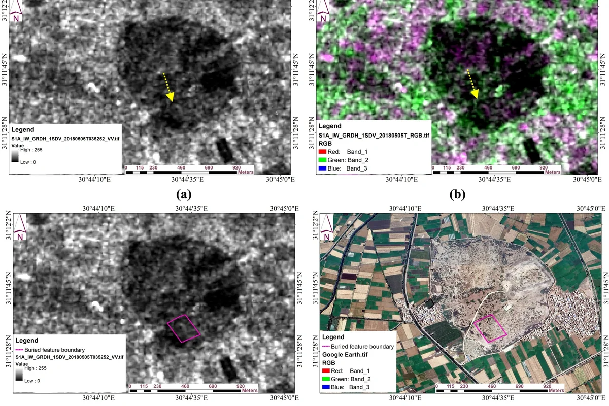
To overcome these hurdles, scientists instead relied on satellite radar (SAR) and analysis of soil electrical resistivity.
Researchers assessed data from the Sentinel-1 radar satellite to identify large-scale anomalies from space.
The satellite constellation consists of probes with high-resolution radar imaging abilities launched between 2014 and 2025.
When the satellite scans hinted at anomalous areas near the Nile, they conducted electrical resistivity tests in those regions to probe further.
For this, they sent current between a series of electrodes placed in the ground, helping create a 3D model of subsurface structures based on how different materials conducted or resisted electricity.
The top three meters of scans in the region showed a layer of broken pottery and debris from the later Roman and Ptolemaic periods.
But at greater depths of between three and six meters, the technology revealed a large, well-defined structure from the Saite period of around 2,600 years ago.
Further excavations over a small 100sqm area revealed mudbrick walls and religious artefacts in areas the sensors had predicted.
"The results of this study demonstrate the effectiveness of combining geophysical measurements and remote sensing data, which gave a very accurate vision in detecting buried settlements in a complex region," researchers wrote in the study published in the journal Acta Geophysica.
"3D inversion algorithms were particularly effective in delineating buried mudbrick walls and architectural structures, significantly enhancing our understanding of site formation processes,” they wrote.
Below this layer, at about 6 to 7m beneath the ground, researchers found a surprisingly thick layer of clean sand.
They suspect ancient builders packed a bottom cushioning layer of clean sand before laying foundations to help spread the weight of buildings.
This seems to follow the same logic as modern load-distributing building foundations.
“At a depth ranging from 3 to 6m, a well-defined high-resistivity anomaly was identified as a Saite period mudbrick structure, possibly a large tomb or shrine, resting on an artificial sand foundation or sandboxes,” scientists wrote.
In ongoing studies, they hope to expand these surveys with larger equipment to reach even deeper, older levels.
“Our findings suggest that, in addition to the known temple, another temple may remain buried under a thick clay layer,” researchers wrote in the study.
Such an integrated approach can help accurately map other archaeological sites before beginning excavations, they say.