Hurricane Polo Spaghetti Models Show Potential Paths As Storm Intensifies - Newsweek
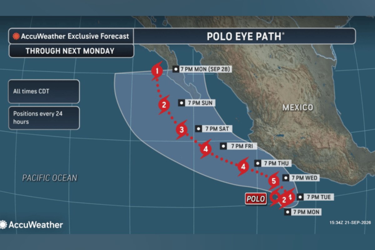
Hurricane Polo is expected to move northward up the coast of Mexico over the coming days, as forecasters upgraded the system to a Category 5 hurricane on Tuesday.
"This storm has rapidly intensified into a major hurricane and can continue to intensify through Tuesday," Alex DaSilva, AccuWeather's lead hurricane expert, told Newsweek.
In its latest update on Tuesday, the National Hurricane Center (NHC) said Hurricane Polo was located around 220 miles south of Zihuatanejo, Mexico, and was moving eastwards at around six miles per hour.
The hurricane is then expected to veer toward the northwest on Tuesday night and Wednesday. Forecasters expect the storm to move up Mexico's southwestern coast during the coming days, though it is projected to stay offshore.
The NHC said that the storm's maximum sustained winds had increased to around 160 mph.
"Polo is a category 5 hurricane on the Saffir-Simpson Hurricane Wind Scale. Some additional strengthening is likely through tonight, with fluctuations in strength possible Wednesday and Wednesday night," the agency said.
Polo is expected to produce rainfall totals of four to eight inches across coastal portions of the Mexican states of Guerrero and Michoacán through Thursday, according to the NHC, with totals in some areas reaching 12 inches. The agency warned that the rain could trigger life-threatening flooding and mudslides, particularly in areas with steep terrain.
It also forecasts totals of three to six inches along coastal Oaxaca, Colima and Jalisco through Thursday.
The NHC added that swells generated by the hurricane are also expected to reach portions of southwestern Mexico's coast during the next few days, bringing the risk of life-threatening surf and rip currents.
It said a tropical storm watch was in place for Tecpan de Galeana to Manzanillo, Mexico.
The spaghetti plot above, which shows possible forecast model tracks, depicts the system moving generally west and northwest over the eastern Pacific. The tracks appear to show some divergence as the forecast progresses.
"The track in the long term is very complex as Tropical Storm Odalys will approach from the west," DaSilva explained. "If the two storms get close enough to each other, Odalys can pull Polo more offshore. This could allow Polo to even remain offshore of Mexico entirely with little or no moisture getting pulled into the United States.
"However, if Odalys can’t pull Polo offshore, that could allow the storm to hook more into the Baja Peninsula and possibly bring moisture to the southwestern United States."
The Saffir-Simpson Hurricane Wind Scale rates hurricanes on a scale of Category 1 to Category 5 based on their maximum sustained wind speed, according to the National Oceanic and Atmospheric Administration (NOAA).
Category 1 and 2 hurricanes have sustained winds of 74 to 95 mph and 96 to 110 mph, respectively. Category 3 hurricanes—the point at which systems start to become classified as major hurricanes—have sustained winds of 111-129 mph.
Category 4 storms have winds of 130 to 156 mph, and Category 5 hurricanes have winds of 157 mph or higher.
NOAA describes the potential wind damage from Category 4 and 5 hurricanes as "catastrophic."
Polo’s formation comes after forecasters predicted a more active Pacific hurricane season this year, thanks in part to the effects of El Niño.
This naturally recurring Pacific climate pattern is known to influence weather conditions worldwide. It can also lead to increased Pacific hurricane activity while suppressing activity in the Atlantic.
"El Niño conditions are associated with fewer tropical storms and hurricanes, especially in the Western Atlantic Ocean Basin," Matthew Rosencrans, NOAA’s lead for its seasonal hurricane outlook, told Newsweek previously.
"El Niño conditions are associated with more tropical storm and hurricane activity during the eastern and central Pacific hurricane seasons."
Contact Newsweek editors on this story: Matthew Robinson and Tony Phillips.
Update, 9/22/26, 8:45 a.m. ET: This article was updated with new information and a new headline.