Cyclone Murasu makes landfall, Andhra on alert as storm unleashes 120 kmph winds
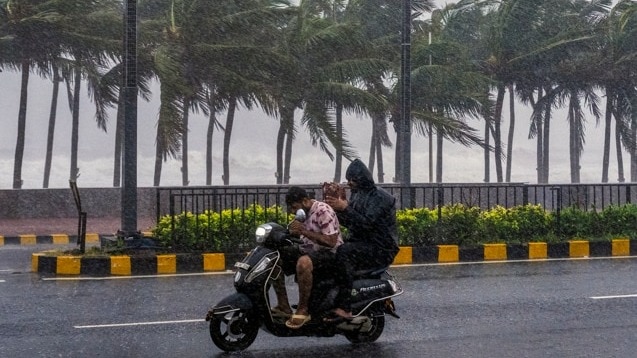
Severe cyclonic storm Murasu began its landfall process near Ongole in Andhra Pradesh's Prakasam district around 1 am on Tuesday, bringing heavy rainfall and gale-force winds of up to 110 kmph, with gusts reaching 120 kmph, the India Meteorological Department (IMD) said.
In its bulletin at 1.30 am, the IMD said the cyclone was centred over the west-central Bay of Bengal, around 40 km southeast of Ongole, 60 km northeast of Kavali and 70 km south of Bapatla. The forward sector of the cyclone's wall cloud had started entering the coast, with the landfall process expected to continue through the early hours. IMD on X
The IMD warned that gale-force winds of 110 kmph, gusting up to 120 kmph, were likely along and off the South Andhra Pradesh coast until morning. Heavy rainfall was also forecast across South Coastal Andhra Pradesh over the next 12 hours.VIDEO | Cyclone Murasu: Trees uprooted as heavy rainfall accompanied by winds lashed the Chirala region in Andhra Pradesh. (Full video available on PTI Videos - https://t.co/d8jp61yd2p) https://t.co/kUb3sZLXoo— Press Trust of India (@PTI_News) November 2, 2026
A storm surge of 1-1.5 metres above the astronomical tide was likely to inundate low-lying areas until Wednesday morning. Bapatla, Krishna and Prakasam districts were expected to witness the maximum impact of the surge.
At least 19 domestic flights across Vijayawada, Tirupati and Visakhapatnam airports were cancelled on Monday as the cyclone approached the Andhra Pradesh coast.
Andhra Pradesh Chief Minister N Chandrababu Naidu has directed officials to remain on high alert and take all necessary precautionary measures to prevent loss of life and property.
During a review meeting on Monday, Naidu said the impact of Murasu was likely to be less severe than Cyclone Arnab but stressed the need for effective preparedness as moderate to heavy rainfall was expected across South Coastal Andhra and Rayalaseema districts.
Officials informed him that Palnadu could receive the highest rainfall of around 30 cm, followed by Prakasam with 24 cm and Markapuram with 19 cm. Krishna, Guntur, Eluru and Nellore districts could receive up to 9 cm of rainfall.
The Chief Minister also directed officials to ensure the safety of nearly 6,800 tanks across six potentially affected districts. He called for adequate water management arrangements and instructed officials to activate Water Users Associations, monitor tank conditions and take preventive steps to avoid breaches and crop inundation.31,000 ELECTRICITY POLES DISPATCHED, RESTORATION TEAMS ON STANDBY
The state government has put arrangements in place to deal with possible electricity disruptions. Officials informed Naidu that 31,000 electricity poles had been dispatched to the field from Srikakulam to Krishna district, while around 8,000 poles in South Coastal Andhra and Rayalaseema could be affected.
Around 1,000 personnel were also arriving from Chennai to assist with electricity restoration.
Naidu directed officials to complete post-cyclone restoration work within 48 hours and expedite crop insurance compensation and input subsidy processes.
Meanwhile, Karnataka Deputy Chief Minister D K Shivakumar announced that his state would deploy 500 skilled electricity workers, along with equipment, to Andhra Pradesh to assist with power restoration.
Shivakumar said he had spoken to Naidu and assured him of Karnataka's support. He added that the state would continue to assess the situation and extend assistance wherever required.19 FLIGHTS CANCELLED AS CYCLONE APPROACHES ANDHRA COAST
At least 19 domestic flights were cancelled across Vijayawada, Tirupati and Visakhapatnam airports on Monday due to the approaching cyclone.
Vijayawada Airport Director M Lakshmi Kantha Reddy said IndiGo had cancelled 10 flights and Air India Express two. At Visakhapatnam airport, four flights were cancelled, while IndiGo also cancelled flights connecting Tirupati with Vijayawada, Visakhapatnam and Bengaluru, airport officials said.
The cancellations came amid warnings of strong winds and widespread rainfall across the state.TAMIL NADU BRACES FOR HEAVY TO VERY HEAVY RAINFALL
Meanwhile, the IMD has warned of heavy to very heavy rainfall in several parts of Tamil Nadu over the next 24 hours as Murasu moves towards the South Andhra Pradesh coast.
Chennai and Tiruvallur are expected to receive continuous heavy to very heavy rainfall. Heavy rain has also been forecast in Chengalpattu, Kancheepuram, Ranipet, Vellore and the Nilgiris districts. Rainfall intensity is expected to gradually decrease after the cyclone completes its landfall.#WATCH | Puducherry: Continuous rainfall has been reported in Puducherry since midnight under the impact of Cyclone Murasu, affecting normal life. The outer rain bands of the cyclone are currently affecting North Tamil Nadu and Puducherry. The IMD has forecast that the cyclone will intensify into a very severe cyclonic storm and cross the Andhra Pradesh coast between Nellore and Narsapur, near Ongole, during the early hours of November 3.— ANI (@ANI) November 2, 2026
The IMD said major sea surges were unlikely along the North Tamil Nadu coast but advised fishermen against venturing into the sea due to rough conditions and squally winds that could reach 80 kmph.
Residents in affected areas have been advised to remain indoors and follow instructions issued by local authorities.- Ends